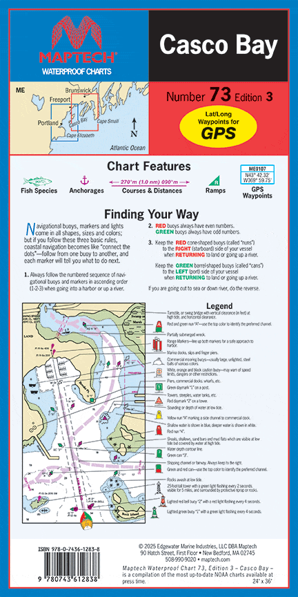
Casco Bay Waterproof Chart, 2nd Edition
Embark on your nautical adventures with the Casco Bay Waterproof Chart, 2nd Edition. This meticulously crafted chart is designed for both seasoned sailors and casual boaters, making it an essential tool for exploring the stunning waterways of Casco Bay.
This Waterproof Chart measures a generous 24" x 36" and is detailed at a scale of 1:36,000, providing you with a comprehensive view of the area's marine landscape. With this chart in hand, you can navigate the bay with confidence, knowing that you have accurate and detailed information at your fingertips.
Key features of the Casco Bay Waterproof Chart include:
- Features waypoints for major buoys, helping you stay on course.
- Includes essential ramp locations for easy boat launch and retrieval.
Not only is this chart practical, but it is also waterproof, ensuring durability in wet conditions. Whether you’re caught in a light rain or splashed by waves, your navigation chart will remain in pristine condition. The clarity and detail of the printed graphics allow for easy reading and understanding, even from a distance.
Don't let the fear of getting lost dampen your maritime adventures. Equip yourself with the Casco Bay Waterproof Chart and navigate through the beautiful waters with ease. It's more than just a chart; it's your gateway to exploration and discovery in one of Maine's most picturesque locations.
Original : $27.95
-70%$27.95
$8.38Description
Embark on your nautical adventures with the Casco Bay Waterproof Chart, 2nd Edition. This meticulously crafted chart is designed for both seasoned sailors and casual boaters, making it an essential tool for exploring the stunning waterways of Casco Bay.
This Waterproof Chart measures a generous 24" x 36" and is detailed at a scale of 1:36,000, providing you with a comprehensive view of the area's marine landscape. With this chart in hand, you can navigate the bay with confidence, knowing that you have accurate and detailed information at your fingertips.
Key features of the Casco Bay Waterproof Chart include:
- Features waypoints for major buoys, helping you stay on course.
- Includes essential ramp locations for easy boat launch and retrieval.
Not only is this chart practical, but it is also waterproof, ensuring durability in wet conditions. Whether you’re caught in a light rain or splashed by waves, your navigation chart will remain in pristine condition. The clarity and detail of the printed graphics allow for easy reading and understanding, even from a distance.
Don't let the fear of getting lost dampen your maritime adventures. Equip yourself with the Casco Bay Waterproof Chart and navigate through the beautiful waters with ease. It's more than just a chart; it's your gateway to exploration and discovery in one of Maine's most picturesque locations.


