West Grand Bahama and Berry Islands Navigation Chart 38G
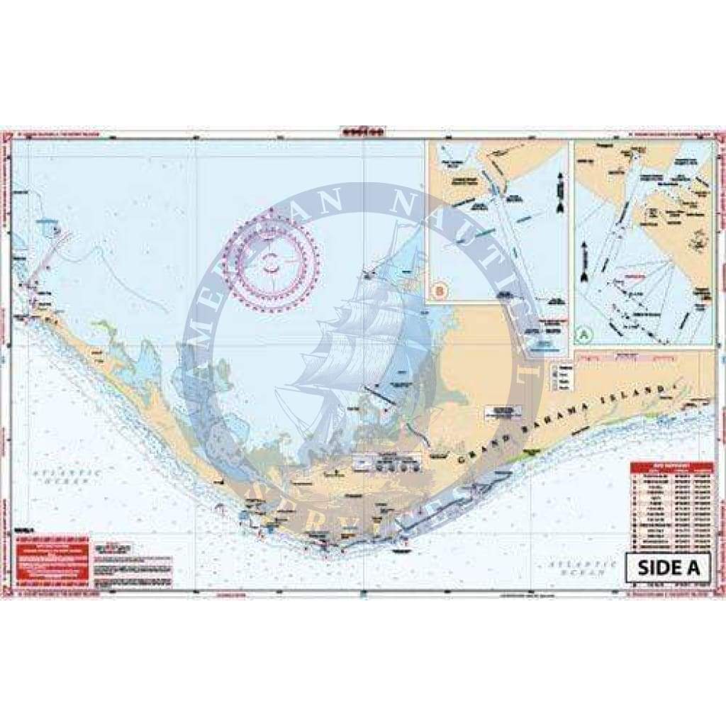
Detailed coverage for the west portion of Grand Bahama Island from the Missle Base east. Includes the Grand Bahama Waterway, all southside marinas and canals, and the Commercial Harbor. Waypoints are provided for all harbor entrances and for the Indian Key Channel. An added red pattern details the south side barrier reef. Detail entrance diagram for Port Lucaya. The reverse side covers the Berry Islands in detail from Great Stirrup south to Chub Cay. Inside routes and shallow areas have been added with GPS Coordinates. Lights damaged by Hurricane Andrew have been noted.No trip to the Bahamas is complete without this Western Bahamas map. And we’re not just saying that. We have provided detailed coverage for the west portion of Grand Bahama Island from the Missle Base east. This navigation chart also includes the Grand Bahama Waterway, all southside marinas and canals, and the Commercial Harbor. Waypoints are provided for all harbor entrances and for the Indian Key Channel. An added red pattern details the south side barrier reef. There is also a detailed entrance diagram for Port Lucaya on this navigation map. The reverse side covers the Berry Islands in detail from Great Stirrup south to Chub Cay. Inside routes and shallow areas have been added with GPS coordinates. Lights damaged by Hurricane Andrew have been noted to assist with navigation. Information from 2 DMA Charts# 26323 and #26328, sketch charts, and harbor diagrams. Extensive input from local authorities and ISS field work, and over 60 GPS Waypoints. The combination of pristine detail and bright colors makes this nautical map excellent for framing and decorating a home or office. Nautical Chart is 25″ X 38″. WGS84 – World Mercator Datum.
Detailed coverage for the west portion of Grand Bahama Island from the Missle Base east. Includes the Grand Bahama Waterway, all southside marinas and canals, and the Commercial Harbor. Waypoints are provided for all harbor entrances and for the Indian Key Channel. An added red pattern details the south side barrier reef. Detail entrance diagram for Port Lucaya. The reverse side covers the Berry Islands in detail from Great Stirrup south to Chub Cay. Inside routes and shallow areas have been added with GPS Coordinates. Lights damaged by Hurricane Andrew have been noted.No trip to the Bahamas is complete without this Western Bahamas map. And we’re not just saying that. We have provided detailed coverage for the west portion of Grand Bahama Island from the Missle Base east. This navigation chart also includes the Grand Bahama Waterway, all southside marinas and canals, and the Commercial Harbor. Waypoints are provided for all harbor entrances and for the Indian Key Channel. An added red pattern details the south side barrier reef. There is also a detailed entrance diagram for Port Lucaya on this navigation map. The reverse side covers the Berry Islands in detail from Great Stirrup south to Chub Cay. Inside routes and shallow areas have been added with GPS coordinates. Lights damaged by Hurricane Andrew have been noted to assist with navigation. Information from 2 DMA Charts# 26323 and #26328, sketch charts, and harbor diagrams. Extensive input from local authorities and ISS field work, and over 60 GPS Waypoints. The combination of pristine detail and bright colors makes this nautical map excellent for framing and decorating a home or office. Nautical Chart is 25″ X 38″. WGS84 – World Mercator Datum.
Description
Detailed coverage for the west portion of Grand Bahama Island from the Missle Base east. Includes the Grand Bahama Waterway, all southside marinas and canals, and the Commercial Harbor. Waypoints are provided for all harbor entrances and for the Indian Key Channel. An added red pattern details the south side barrier reef. Detail entrance diagram for Port Lucaya. The reverse side covers the Berry Islands in detail from Great Stirrup south to Chub Cay. Inside routes and shallow areas have been added with GPS Coordinates. Lights damaged by Hurricane Andrew have been noted.No trip to the Bahamas is complete without this Western Bahamas map. And we’re not just saying that. We have provided detailed coverage for the west portion of Grand Bahama Island from the Missle Base east. This navigation chart also includes the Grand Bahama Waterway, all southside marinas and canals, and the Commercial Harbor. Waypoints are provided for all harbor entrances and for the Indian Key Channel. An added red pattern details the south side barrier reef. There is also a detailed entrance diagram for Port Lucaya on this navigation map. The reverse side covers the Berry Islands in detail from Great Stirrup south to Chub Cay. Inside routes and shallow areas have been added with GPS coordinates. Lights damaged by Hurricane Andrew have been noted to assist with navigation. Information from 2 DMA Charts# 26323 and #26328, sketch charts, and harbor diagrams. Extensive input from local authorities and ISS field work, and over 60 GPS Waypoints. The combination of pristine detail and bright colors makes this nautical map excellent for framing and decorating a home or office. Nautical Chart is 25″ X 38″. WGS84 – World Mercator Datum.


