1 / 2
San Francisco to Mexico Navigation Chart 54
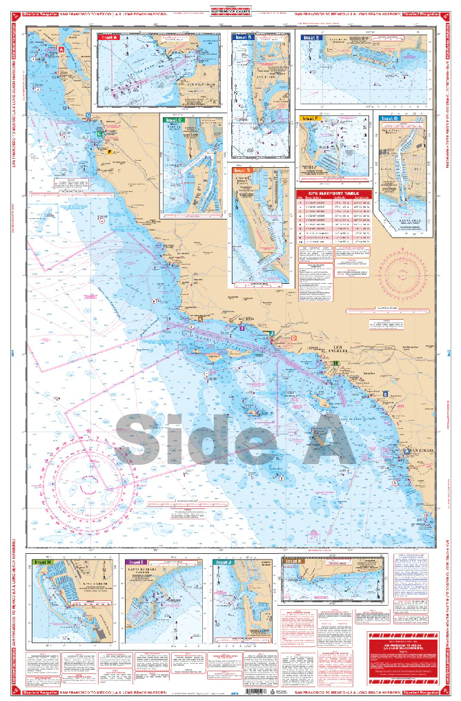
A terrific combination of 10 NOAA charts. Complete coverage of the California coast from San Francisco Bay south to Cabo Punta Banda, Mexico. Reverse side is detail for Los Angeles and Long Beach harbors with detail blow up for Anaheim Bay-Huntington Harbor. Harbor blow- ups for King Harbor, Santa Barbara Harbor, Ventura Harbor, Point Conception, San Francisco Bay Entrance, San Diego, Moss Landing, Channel Island Harbor and Santa Cruz Harbor. A total of 23 plotted GPS Waypoints. This is a terrific combination of 10 NOAA charts to provide excellent coverage of the Pacific Coast from San Fransisco Bay to Mexico. You will be confident in your ability to traverse the waters in this area no matter if it’s a week long trip or just a few hours on the water. This navigation map has complete coverage of the California coast from San Francisco Bay south to Cabo Punta Banda, Mexico.The reverse side of this navigation chart has detail for Los Angeles and Long Beach harbors with detail blow up for Anaheim Bay-Huntington Harbor. Harbor blow- ups for King Harbor, Santa Barbara Harbor, Ventura Harbor, Point Conception, San Francisco Bay Entrance, San Diego, Moss Landing, Channel Island Harbor and Santa Cruz Harbor. A total of 23 plotted GPS Waypoints will help you easily set up your GPS unit before you even leave the dock. Get this vibrant California coast map framed to display in your home or office. Information from 10 NOAA charts: #18749, #18751, #18744, #18645, #18022, #18746, #18685, #18725, #18765, #18721. Nautical Chart is 25″ X 38″. WGS84 – World Mercator Datum.
A terrific combination of 10 NOAA charts. Complete coverage of the California coast from San Francisco Bay south to Cabo Punta Banda, Mexico. Reverse side is detail for Los Angeles and Long Beach harbors with detail blow up for Anaheim Bay-Huntington Harbor. Harbor blow- ups for King Harbor, Santa Barbara Harbor, Ventura Harbor, Point Conception, San Francisco Bay Entrance, San Diego, Moss Landing, Channel Island Harbor and Santa Cruz Harbor. A total of 23 plotted GPS Waypoints. This is a terrific combination of 10 NOAA charts to provide excellent coverage of the Pacific Coast from San Fransisco Bay to Mexico. You will be confident in your ability to traverse the waters in this area no matter if it’s a week long trip or just a few hours on the water. This navigation map has complete coverage of the California coast from San Francisco Bay south to Cabo Punta Banda, Mexico.The reverse side of this navigation chart has detail for Los Angeles and Long Beach harbors with detail blow up for Anaheim Bay-Huntington Harbor. Harbor blow- ups for King Harbor, Santa Barbara Harbor, Ventura Harbor, Point Conception, San Francisco Bay Entrance, San Diego, Moss Landing, Channel Island Harbor and Santa Cruz Harbor. A total of 23 plotted GPS Waypoints will help you easily set up your GPS unit before you even leave the dock. Get this vibrant California coast map framed to display in your home or office. Information from 10 NOAA charts: #18749, #18751, #18744, #18645, #18022, #18746, #18685, #18725, #18765, #18721. Nautical Chart is 25″ X 38″. WGS84 – World Mercator Datum.
$27.95
San Francisco to Mexico Navigation Chart 54—
$27.95
Description
A terrific combination of 10 NOAA charts. Complete coverage of the California coast from San Francisco Bay south to Cabo Punta Banda, Mexico. Reverse side is detail for Los Angeles and Long Beach harbors with detail blow up for Anaheim Bay-Huntington Harbor. Harbor blow- ups for King Harbor, Santa Barbara Harbor, Ventura Harbor, Point Conception, San Francisco Bay Entrance, San Diego, Moss Landing, Channel Island Harbor and Santa Cruz Harbor. A total of 23 plotted GPS Waypoints. This is a terrific combination of 10 NOAA charts to provide excellent coverage of the Pacific Coast from San Fransisco Bay to Mexico. You will be confident in your ability to traverse the waters in this area no matter if it’s a week long trip or just a few hours on the water. This navigation map has complete coverage of the California coast from San Francisco Bay south to Cabo Punta Banda, Mexico.The reverse side of this navigation chart has detail for Los Angeles and Long Beach harbors with detail blow up for Anaheim Bay-Huntington Harbor. Harbor blow- ups for King Harbor, Santa Barbara Harbor, Ventura Harbor, Point Conception, San Francisco Bay Entrance, San Diego, Moss Landing, Channel Island Harbor and Santa Cruz Harbor. A total of 23 plotted GPS Waypoints will help you easily set up your GPS unit before you even leave the dock. Get this vibrant California coast map framed to display in your home or office. Information from 10 NOAA charts: #18749, #18751, #18744, #18645, #18022, #18746, #18685, #18725, #18765, #18721. Nautical Chart is 25″ X 38″. WGS84 – World Mercator Datum.


