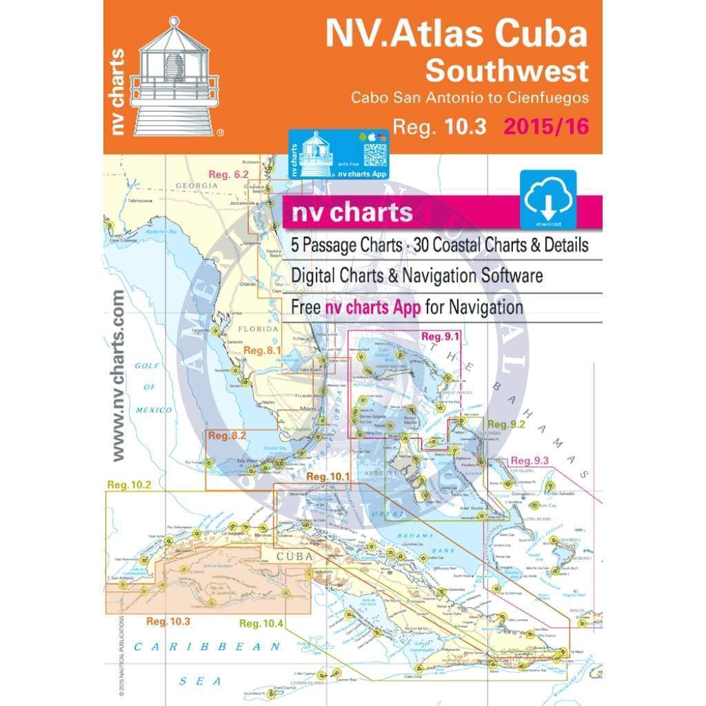
NV. Charts Reg. 10.3 Chart Kit: Cuba Southwest, Cabo de San Antonio to Cienfuegos, 2015/16 Edition
NV-charts Reg. 10.3 Chart Kit: Cuba Southwest, Cabo de San Antonio to Cienfuegos
• Includes Harbour & Anchorage Charts
• 6 Passage Charts - 30 Coastal Charts - 8 Details
• GPS Charted Waypoints
Size [Closed] H (16.5") x W (11,7")
The nv-charts are characterised by fine contours and easy to distinguish colour graduations of the depth lines – turquoise for coral reefs, red for the 2-meter-line and blue for the 5-m-areas. Presented in a handy, user friendly size, a thick plastic envelope protects the charts, enabling them to be easily stored.
The importance of good graphical representation of the topography when sailing in the Caribbean is essential. Well marked rivers, towns and street plans all help to give a clear overall view of the shoreside facilities of the islands.
Red numbered waypoints with coordinates based on WGS 84 enable yachtsmen to navigate using their GPS instruments. Heights and depths are given in the internationally accepted format of meters. Large scale approaches and land contour markings simplify the entrance into anchorages.
Reg 10.3 Cuba Southwest
Passage Charts
C0 Caribbean Sea 1: 6,500,000
C1 Cabo San Antonio to Cienfuegos 1: 900,000
C2 Cabo San Antonio to Golfo de Batabanó 1: 340,000
C3 Cabo Francés to Cayo Avalos 1: 340,000
C4 Cayo Avalos to Cienfuegos 1: 340,000
Coastal Charts
C5 Cabo Francés to Cayos de San Felipe 1: 140,000
C6 Golfo de Batabanó · Cayos de Mangles 1: 140,000
C7 Golfo de Batabanó · Northern Part 1: 140,000
C8 Golfo de Batabanó · Ensenada de la Broa 1: 140,000
C9 Golfo de Batabanó · Cayo Monterrey to Cayo Juan Ruíz 1: 140,000
C10 Golfo de Batabanó · Banco Jardines to Golfo de Cazones 1: 140,000
C11 Isla de la Juventud · Eastern Part 1: 140,000
C12 Cayo Campos to Cayo Largo 1: 140,000
C13 Cayo Largo to Cayo Guano del Este 1: 140,000
C14A Ensenada de la Siguanea 1: 140,000
C14B Golfo de Cazones · Bahía de Cochinos 1: 140,000
Approaches & Details
C15 Cayos de Mangles · Passages 1: 60,000
C15A Isla de la Juventud · Nueva Gerona 1: 20,000
C16 Isla de la Juventud East 1: 60,000
C17 Cayo Coco to Cayo Avalos 1: 60,000
C18 Cayo Avalos to Cayo del Rosario 1: 60,000
C19 Cayo del Rosario to Cayo Largo 1: 60,000
C20A/B La Coloma 1: 20/40,000
C20C Laguna de Cortés 1: 60,000
C20D-F Cayos de San Felipe 1: 20/60,000
C21 Bahía de Cienfuegos 1: 40,000
C22A Approach Cienfuegos 1: 20,000
C22B Surgidero de Batabanó 1: 20,000
C22C Bahía de San Pedro 1: 60,000
C22D Cienfuegos 1: 20,000
C22E Pta. Francés 1: 60,000
C22F Canalizo Cayo Largo 1: 20,000
Description
NV-charts Reg. 10.3 Chart Kit: Cuba Southwest, Cabo de San Antonio to Cienfuegos
• Includes Harbour & Anchorage Charts
• 6 Passage Charts - 30 Coastal Charts - 8 Details
• GPS Charted Waypoints
Size [Closed] H (16.5") x W (11,7")
The nv-charts are characterised by fine contours and easy to distinguish colour graduations of the depth lines – turquoise for coral reefs, red for the 2-meter-line and blue for the 5-m-areas. Presented in a handy, user friendly size, a thick plastic envelope protects the charts, enabling them to be easily stored.
The importance of good graphical representation of the topography when sailing in the Caribbean is essential. Well marked rivers, towns and street plans all help to give a clear overall view of the shoreside facilities of the islands.
Red numbered waypoints with coordinates based on WGS 84 enable yachtsmen to navigate using their GPS instruments. Heights and depths are given in the internationally accepted format of meters. Large scale approaches and land contour markings simplify the entrance into anchorages.
Reg 10.3 Cuba Southwest
Passage Charts
C0 Caribbean Sea 1: 6,500,000
C1 Cabo San Antonio to Cienfuegos 1: 900,000
C2 Cabo San Antonio to Golfo de Batabanó 1: 340,000
C3 Cabo Francés to Cayo Avalos 1: 340,000
C4 Cayo Avalos to Cienfuegos 1: 340,000
Coastal Charts
C5 Cabo Francés to Cayos de San Felipe 1: 140,000
C6 Golfo de Batabanó · Cayos de Mangles 1: 140,000
C7 Golfo de Batabanó · Northern Part 1: 140,000
C8 Golfo de Batabanó · Ensenada de la Broa 1: 140,000
C9 Golfo de Batabanó · Cayo Monterrey to Cayo Juan Ruíz 1: 140,000
C10 Golfo de Batabanó · Banco Jardines to Golfo de Cazones 1: 140,000
C11 Isla de la Juventud · Eastern Part 1: 140,000
C12 Cayo Campos to Cayo Largo 1: 140,000
C13 Cayo Largo to Cayo Guano del Este 1: 140,000
C14A Ensenada de la Siguanea 1: 140,000
C14B Golfo de Cazones · Bahía de Cochinos 1: 140,000
Approaches & Details
C15 Cayos de Mangles · Passages 1: 60,000
C15A Isla de la Juventud · Nueva Gerona 1: 20,000
C16 Isla de la Juventud East 1: 60,000
C17 Cayo Coco to Cayo Avalos 1: 60,000
C18 Cayo Avalos to Cayo del Rosario 1: 60,000
C19 Cayo del Rosario to Cayo Largo 1: 60,000
C20A/B La Coloma 1: 20/40,000
C20C Laguna de Cortés 1: 60,000
C20D-F Cayos de San Felipe 1: 20/60,000
C21 Bahía de Cienfuegos 1: 40,000
C22A Approach Cienfuegos 1: 20,000
C22B Surgidero de Batabanó 1: 20,000
C22C Bahía de San Pedro 1: 60,000
C22D Cienfuegos 1: 20,000
C22E Pta. Francés 1: 60,000
C22F Canalizo Cayo Largo 1: 20,000


