NV. Charts Reg. 10.2 Chart Kit: Cuba Northwest, Varadero, Havana to Cabo San Antonio, 2015/16 Edition
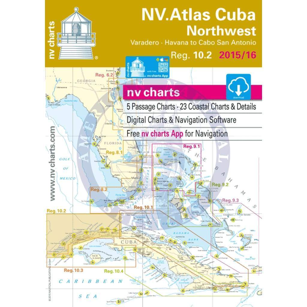
NV-charts Reg. 10.2 Chart Kit: Cuba Northwest • Varadero • Habanna to Cabo San Antonio
• Includes Harbour & Anchorage Charts
• 5 Passage Charts - 23 Coastal Charts + Details
• GPS Charted Waypoints - Approaches
Size [Closed] H (16.5") x W (11,7")
The nv-charts are characterized by fine contours and easy to distinguish colour graduations of the depth lines – turquoise for coral reefs, red for the 2-meter-line and blue for the 5-m-areas. Presented in a handy, user friendly size, a thick plastic envelope protects the charts, enabling them to be easily stored.
The importance of good graphical representation of the topography when sailing in the Caribbean is essential. Well marked rivers, towns and street plans all help to give a clear overall view of the shoreside facilities of the islands.
Red numbered waypoints with coordinates based on WGS 84 enable yachtsmen to navigate using their GPS instruments. Heights and depths are given in the internationally accepted format of meters. Large scale approaches and land contour markings simplify the entrance into anchorages.
Reg. 10.2 Cuba Northwest
Passage Charts
C0 Caribbean Sea 1: 6,500,000
C1 Cabo San Antonio · Key West · Varadero 1: 900,000
C2 Cabo San Antonio to Cayo Jutías 1: 340,000
C3 Cayo Jutías to La Habana 1: 340,000
C4 La Habana to Varadero 1: 340,000
Coastal Charts
C5 Golfo de Guanahacabibes South 1: 140,000
C6 Golfo de Guanahacabibes North 1: 140,000
C7 Cabezo Seco to Cayo Arenas 1: 140,000
C8 Cayo Arenas to Bahía Honda 1: 140,000
C9 Bahía Honda to La Habana 1: 140,000
C10 La Habana to Canasí 1: 140,000
C11 Canasí to Varadero 1: 140,000
Approaches & Details
C12 Ensenada de Guadiana 1: 60,000
C13 El Pinto to Pta. Tabaco 1: 60,000
C14 Pta. Tabaco to Cayo Jutías 1: 60,000
C15 Cayo Jutías to Cayo Inés de Soto 1: 60,000
C16 Cayo Inés de Soto to Cayos Alacranes 1: 60,000
C17 Cayos Alacranes to Bahía Honda 1: 60,000
C18 Marina Hemingway to La Habana 1: 60,000
C19 Varadero 1: 60,000
C20 Pasa Los Morros 1: 60,000
C20A Pasa Buenavista 1: 40,000
C20B Bahía Honda 1: 40,000
C21 Bahía de Cabañas 1: 40,000
C21A Puerto del Mariel 1: 40,000
C21B Bahía de Matanzas 1: 40,000
C22 La Habana 1: 20,000
C22A Marina Hemingway 1: 15,000
$6,800.00
NV. Charts Reg. 10.2 Chart Kit: Cuba Northwest, Varadero, Havana to Cabo San Antonio, 2015/16 Edition—
$6,800.00
Description
NV-charts Reg. 10.2 Chart Kit: Cuba Northwest • Varadero • Habanna to Cabo San Antonio
• Includes Harbour & Anchorage Charts
• 5 Passage Charts - 23 Coastal Charts + Details
• GPS Charted Waypoints - Approaches
Size [Closed] H (16.5") x W (11,7")
The nv-charts are characterized by fine contours and easy to distinguish colour graduations of the depth lines – turquoise for coral reefs, red for the 2-meter-line and blue for the 5-m-areas. Presented in a handy, user friendly size, a thick plastic envelope protects the charts, enabling them to be easily stored.
The importance of good graphical representation of the topography when sailing in the Caribbean is essential. Well marked rivers, towns and street plans all help to give a clear overall view of the shoreside facilities of the islands.
Red numbered waypoints with coordinates based on WGS 84 enable yachtsmen to navigate using their GPS instruments. Heights and depths are given in the internationally accepted format of meters. Large scale approaches and land contour markings simplify the entrance into anchorages.
Reg. 10.2 Cuba Northwest
Passage Charts
C0 Caribbean Sea 1: 6,500,000
C1 Cabo San Antonio · Key West · Varadero 1: 900,000
C2 Cabo San Antonio to Cayo Jutías 1: 340,000
C3 Cayo Jutías to La Habana 1: 340,000
C4 La Habana to Varadero 1: 340,000
Coastal Charts
C5 Golfo de Guanahacabibes South 1: 140,000
C6 Golfo de Guanahacabibes North 1: 140,000
C7 Cabezo Seco to Cayo Arenas 1: 140,000
C8 Cayo Arenas to Bahía Honda 1: 140,000
C9 Bahía Honda to La Habana 1: 140,000
C10 La Habana to Canasí 1: 140,000
C11 Canasí to Varadero 1: 140,000
Approaches & Details
C12 Ensenada de Guadiana 1: 60,000
C13 El Pinto to Pta. Tabaco 1: 60,000
C14 Pta. Tabaco to Cayo Jutías 1: 60,000
C15 Cayo Jutías to Cayo Inés de Soto 1: 60,000
C16 Cayo Inés de Soto to Cayos Alacranes 1: 60,000
C17 Cayos Alacranes to Bahía Honda 1: 60,000
C18 Marina Hemingway to La Habana 1: 60,000
C19 Varadero 1: 60,000
C20 Pasa Los Morros 1: 60,000
C20A Pasa Buenavista 1: 40,000
C20B Bahía Honda 1: 40,000
C21 Bahía de Cabañas 1: 40,000
C21A Puerto del Mariel 1: 40,000
C21B Bahía de Matanzas 1: 40,000
C22 La Habana 1: 20,000
C22A Marina Hemingway 1: 15,000
• Includes Harbour & Anchorage Charts
• 5 Passage Charts - 23 Coastal Charts + Details
• GPS Charted Waypoints - Approaches
Size [Closed] H (16.5") x W (11,7")
The nv-charts are characterized by fine contours and easy to distinguish colour graduations of the depth lines – turquoise for coral reefs, red for the 2-meter-line and blue for the 5-m-areas. Presented in a handy, user friendly size, a thick plastic envelope protects the charts, enabling them to be easily stored.
The importance of good graphical representation of the topography when sailing in the Caribbean is essential. Well marked rivers, towns and street plans all help to give a clear overall view of the shoreside facilities of the islands.
Red numbered waypoints with coordinates based on WGS 84 enable yachtsmen to navigate using their GPS instruments. Heights and depths are given in the internationally accepted format of meters. Large scale approaches and land contour markings simplify the entrance into anchorages.
Reg. 10.2 Cuba Northwest
Passage Charts
C0 Caribbean Sea 1: 6,500,000
C1 Cabo San Antonio · Key West · Varadero 1: 900,000
C2 Cabo San Antonio to Cayo Jutías 1: 340,000
C3 Cayo Jutías to La Habana 1: 340,000
C4 La Habana to Varadero 1: 340,000
Coastal Charts
C5 Golfo de Guanahacabibes South 1: 140,000
C6 Golfo de Guanahacabibes North 1: 140,000
C7 Cabezo Seco to Cayo Arenas 1: 140,000
C8 Cayo Arenas to Bahía Honda 1: 140,000
C9 Bahía Honda to La Habana 1: 140,000
C10 La Habana to Canasí 1: 140,000
C11 Canasí to Varadero 1: 140,000
Approaches & Details
C12 Ensenada de Guadiana 1: 60,000
C13 El Pinto to Pta. Tabaco 1: 60,000
C14 Pta. Tabaco to Cayo Jutías 1: 60,000
C15 Cayo Jutías to Cayo Inés de Soto 1: 60,000
C16 Cayo Inés de Soto to Cayos Alacranes 1: 60,000
C17 Cayos Alacranes to Bahía Honda 1: 60,000
C18 Marina Hemingway to La Habana 1: 60,000
C19 Varadero 1: 60,000
C20 Pasa Los Morros 1: 60,000
C20A Pasa Buenavista 1: 40,000
C20B Bahía Honda 1: 40,000
C21 Bahía de Cabañas 1: 40,000
C21A Puerto del Mariel 1: 40,000
C21B Bahía de Matanzas 1: 40,000
C22 La Habana 1: 20,000
C22A Marina Hemingway 1: 15,000


