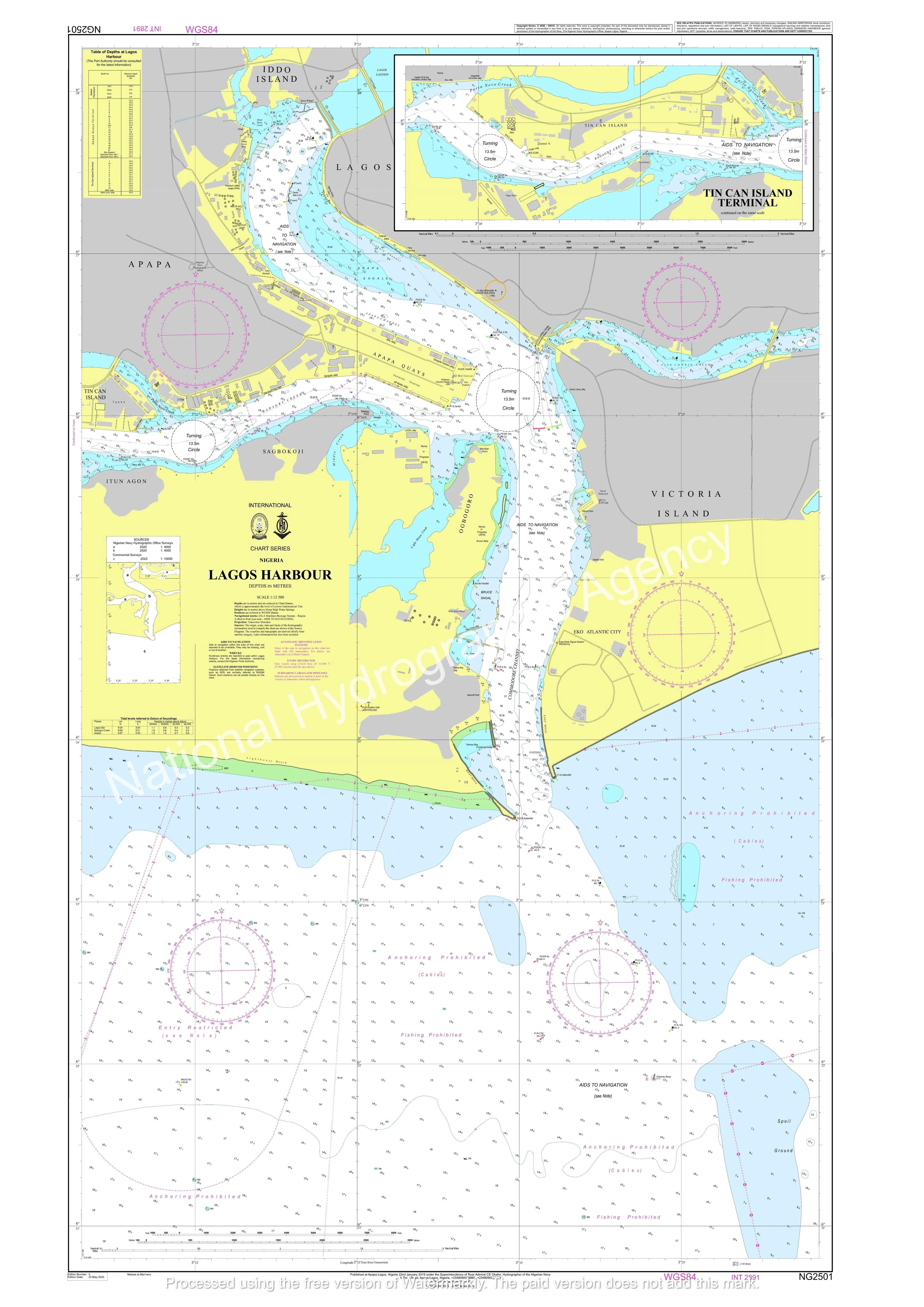
Nigerian Nautical Chart NG2501: Lagos Harbour
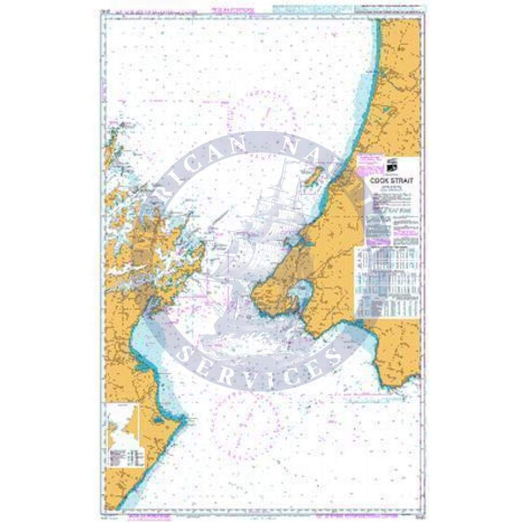
The Nigerian Nautical Chart NG2501 – Lagos Harbour provides detailed hydrographic coverage of Lagos Harbour and its surrounding approaches, supporting safe navigation within one of West Africa’s busiest maritime gateways. Published by the Nigerian Navy Hydrographic Office (NNHO), this official chart contains authoritative navigational information developed from hydrographic surveys and maintained through Notices to Mariners.
This chart is an essential navigation tool for vessels entering or operating within Lagos Harbour, including commercial shipping, offshore support vessels, and regional maritime traffic. It includes critical information such as harbour limits, channels, depths, aids to navigation, port facilities, and navigational hazards, enabling mariners to safely plan and execute harbor approaches and maneuvers.
Lagos Harbour serves as the primary maritime hub for Nigeria’s commercial ports, including Tin Can Island and the Lagos Port Complex, making this chart particularly valuable for port captains, pilots, and vessels operating along the Gulf of Guinea trade routes. The chart is produced in accordance with international hydrographic standards and supports safe passage planning in accordance with SOLAS carriage requirements for nautical charts.
Each chart supplied by American Nautical Services is printed on demand and corrected to the latest available Notices to Mariners, ensuring that mariners receive the most current navigational information available at the time of purchase.
Key Features
-
Official Nigerian nautical chart published by the Nigerian Navy Hydrographic Office
-
Detailed coverage of Lagos Harbour and port approaches
-
Includes depths, channels, aids to navigation, hazards, and port infrastructure
-
Supports safe navigation and voyage planning in Nigerian waters
-
Corrected to the latest Notices to Mariners at time of printing
-
Suitable for commercial vessels, offshore operators, and professional mariners
Important Note:
This chart should be used in conjunction with other relevant nautical charts, sailing directions, and navigational publications covering the approaches to Lagos and the Gulf of Guinea.
Original : $39.95
-70%$39.95
$11.99Description
The Nigerian Nautical Chart NG2501 – Lagos Harbour provides detailed hydrographic coverage of Lagos Harbour and its surrounding approaches, supporting safe navigation within one of West Africa’s busiest maritime gateways. Published by the Nigerian Navy Hydrographic Office (NNHO), this official chart contains authoritative navigational information developed from hydrographic surveys and maintained through Notices to Mariners.
This chart is an essential navigation tool for vessels entering or operating within Lagos Harbour, including commercial shipping, offshore support vessels, and regional maritime traffic. It includes critical information such as harbour limits, channels, depths, aids to navigation, port facilities, and navigational hazards, enabling mariners to safely plan and execute harbor approaches and maneuvers.
Lagos Harbour serves as the primary maritime hub for Nigeria’s commercial ports, including Tin Can Island and the Lagos Port Complex, making this chart particularly valuable for port captains, pilots, and vessels operating along the Gulf of Guinea trade routes. The chart is produced in accordance with international hydrographic standards and supports safe passage planning in accordance with SOLAS carriage requirements for nautical charts.
Each chart supplied by American Nautical Services is printed on demand and corrected to the latest available Notices to Mariners, ensuring that mariners receive the most current navigational information available at the time of purchase.
Key Features
-
Official Nigerian nautical chart published by the Nigerian Navy Hydrographic Office
-
Detailed coverage of Lagos Harbour and port approaches
-
Includes depths, channels, aids to navigation, hazards, and port infrastructure
-
Supports safe navigation and voyage planning in Nigerian waters
-
Corrected to the latest Notices to Mariners at time of printing
-
Suitable for commercial vessels, offshore operators, and professional mariners
Important Note:
This chart should be used in conjunction with other relevant nautical charts, sailing directions, and navigational publications covering the approaches to Lagos and the Gulf of Guinea.