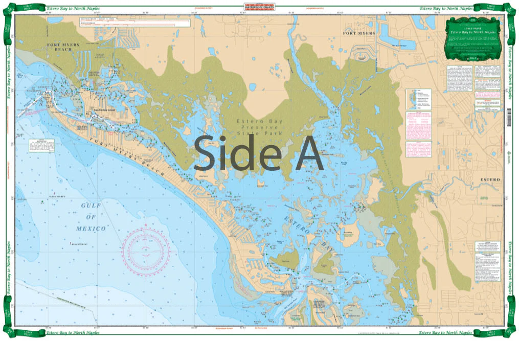
The Estero Bay to North Naples Nautical Chart has detailed coverage of this shallow area with local names and channels. The north side covers Fort Myers Beach, Matanzas Pass, Hurricane Bay, Estero Island and north Estero Bay to Mound Key, including the Hendry Creek, Mullock Creek, the Estero River, Big Carlos Pass, and the Lovers Key State Park area. The south side covers southern Estero Bay, Spring Creek, Fish Trap Bay, New Pass south thru Bonita Beach and the Vanderbilt Channel and Outer Clam Bay. Continues south thru inside route behind Wiggins Pass with complete marker detail and south to the Vanderbilt Beach waterways and canals. Extensive field work details channels and markers available from no other source. Information from county sources, NOAA charts, USGS topographical maps and local experts. Beautiful colors make it suitable for framing. WGS84-World Mercator Datum.
Estero Bay to North Naples 20E
The Estero Bay to North Naples Nautical Chart has detailed coverage of this shallow area with local names and channels. The north side covers Fort Myers Beach, Matanzas Pass, Hurricane Bay, Estero Island and north Estero Bay to Mound Key, including the Hendry Creek, Mullock Creek, the Estero River, Big Carlos Pass, and the Lovers Key State Park area. The south side covers southern Estero Bay, Spring Creek, Fish Trap Bay, New Pass south thru Bonita Beach and the Vanderbilt Channel and Outer Clam Bay. Continues south thru inside route behind Wiggins Pass with complete marker detail and south to the Vanderbilt Beach waterways and canals. Extensive field work details channels and markers available from no other source. Information from county sources, NOAA charts, USGS topographical maps and local experts. Beautiful colors make it suitable for framing. WGS84-World Mercator Datum.
Description
The Estero Bay to North Naples Nautical Chart has detailed coverage of this shallow area with local names and channels. The north side covers Fort Myers Beach, Matanzas Pass, Hurricane Bay, Estero Island and north Estero Bay to Mound Key, including the Hendry Creek, Mullock Creek, the Estero River, Big Carlos Pass, and the Lovers Key State Park area. The south side covers southern Estero Bay, Spring Creek, Fish Trap Bay, New Pass south thru Bonita Beach and the Vanderbilt Channel and Outer Clam Bay. Continues south thru inside route behind Wiggins Pass with complete marker detail and south to the Vanderbilt Beach waterways and canals. Extensive field work details channels and markers available from no other source. Information from county sources, NOAA charts, USGS topographical maps and local experts. Beautiful colors make it suitable for framing. WGS84-World Mercator Datum.


