Central Bahamas – Bimini to Georgetown Navigation Chart 38C
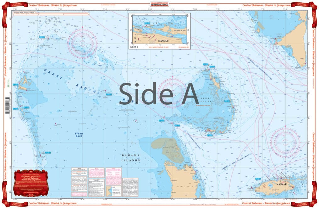
The clearest overall view of the Central Bahamas! Covers area from Bimini east to South Abaco (Hole in the Wall) and south to Nassau on one side with a detailed blow up of Nassau Harbor. Includes all the Berry Islands and North Andros. The reverse side begins at Nassau and continues east to Eleuthra and south thru the Exumas to Great Exuma and Georgetown! Continuous coverage of Eleuthra. Detailed blow ups for Georgetown, Ships Channel, Allen and Highbourn Cay in the Exumas and Harbor Island and Spanish Wells on Eleuthra. A total of 31 sets of GPS Waypoints are plotted directly on the chart. Bright color scheme is very easy to read. The clearest overall view of the Central Bahamas! This map of the Bahamas will help you navigate the waters whether you are just visiting or live here year round. This navigation map covers area from Bimini east to South Abaco (Hole in the Wall) and south to Nassau on one side with a detailed blow up of Nassau Harbor. Includes all the Berry Islands and North Andros. The reverse side begins at Nassau and continues east to Eleuthra and south thru the Exumas to Great Exuma and Georgetown. Also includes, continuous coverage of Eleuthra. Detailed blow ups for Georgetown, Ships Channel, Allen and Highbourn Cay in the Exumas and Harbor Island and Spanish Wells on Eleuthra allow for a better view. A total of 31 sets of GPS Waypoints are plotted directly on the navigation chart. Bright color scheme is very easy to read. These vibrant colors also make this Bahamas chart well suited for framing and displaying on a home or office wall. Information from 6 different DMA charts: #26320, #26309, #26286, #26306, #26300, & #26282. Nautical Chart is 25″ X 38″. WGS84 – World Mercator Datum.
The clearest overall view of the Central Bahamas! Covers area from Bimini east to South Abaco (Hole in the Wall) and south to Nassau on one side with a detailed blow up of Nassau Harbor. Includes all the Berry Islands and North Andros. The reverse side begins at Nassau and continues east to Eleuthra and south thru the Exumas to Great Exuma and Georgetown! Continuous coverage of Eleuthra. Detailed blow ups for Georgetown, Ships Channel, Allen and Highbourn Cay in the Exumas and Harbor Island and Spanish Wells on Eleuthra. A total of 31 sets of GPS Waypoints are plotted directly on the chart. Bright color scheme is very easy to read. The clearest overall view of the Central Bahamas! This map of the Bahamas will help you navigate the waters whether you are just visiting or live here year round. This navigation map covers area from Bimini east to South Abaco (Hole in the Wall) and south to Nassau on one side with a detailed blow up of Nassau Harbor. Includes all the Berry Islands and North Andros. The reverse side begins at Nassau and continues east to Eleuthra and south thru the Exumas to Great Exuma and Georgetown. Also includes, continuous coverage of Eleuthra. Detailed blow ups for Georgetown, Ships Channel, Allen and Highbourn Cay in the Exumas and Harbor Island and Spanish Wells on Eleuthra allow for a better view. A total of 31 sets of GPS Waypoints are plotted directly on the navigation chart. Bright color scheme is very easy to read. These vibrant colors also make this Bahamas chart well suited for framing and displaying on a home or office wall. Information from 6 different DMA charts: #26320, #26309, #26286, #26306, #26300, & #26282. Nautical Chart is 25″ X 38″. WGS84 – World Mercator Datum.
Original : $27.95
-70%$27.95
$8.38Description
The clearest overall view of the Central Bahamas! Covers area from Bimini east to South Abaco (Hole in the Wall) and south to Nassau on one side with a detailed blow up of Nassau Harbor. Includes all the Berry Islands and North Andros. The reverse side begins at Nassau and continues east to Eleuthra and south thru the Exumas to Great Exuma and Georgetown! Continuous coverage of Eleuthra. Detailed blow ups for Georgetown, Ships Channel, Allen and Highbourn Cay in the Exumas and Harbor Island and Spanish Wells on Eleuthra. A total of 31 sets of GPS Waypoints are plotted directly on the chart. Bright color scheme is very easy to read. The clearest overall view of the Central Bahamas! This map of the Bahamas will help you navigate the waters whether you are just visiting or live here year round. This navigation map covers area from Bimini east to South Abaco (Hole in the Wall) and south to Nassau on one side with a detailed blow up of Nassau Harbor. Includes all the Berry Islands and North Andros. The reverse side begins at Nassau and continues east to Eleuthra and south thru the Exumas to Great Exuma and Georgetown. Also includes, continuous coverage of Eleuthra. Detailed blow ups for Georgetown, Ships Channel, Allen and Highbourn Cay in the Exumas and Harbor Island and Spanish Wells on Eleuthra allow for a better view. A total of 31 sets of GPS Waypoints are plotted directly on the navigation chart. Bright color scheme is very easy to read. These vibrant colors also make this Bahamas chart well suited for framing and displaying on a home or office wall. Information from 6 different DMA charts: #26320, #26309, #26286, #26306, #26300, & #26282. Nautical Chart is 25″ X 38″. WGS84 – World Mercator Datum.


