Bahamas Crossing – Bimini and West End Navigation Chart 38B
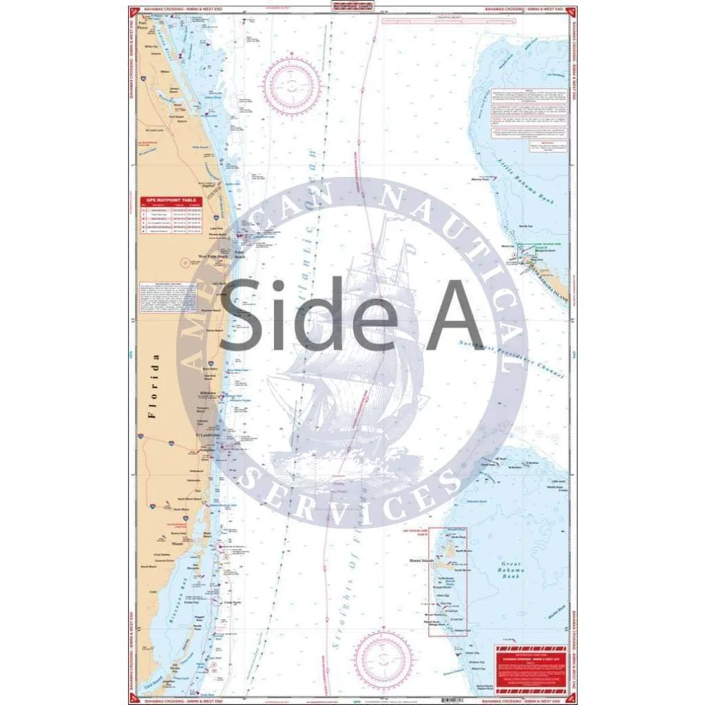
The best chart for crossing to the Bahamas! Details the Florida coast from Jupiter south to Key Largo, and covers the Bimini chain of Islands and the West End of Grand Bahama. Included on this side is a crossing guide. The reverse side has a large blow up of West End, a detailed projection of the Bimini area including Cat Cays, Gun Cay and North Rock and an extra large blow up of South Bimini and Alice Town. GPS Waypoints printed directly on the chart. Three colors for shallow water make this chart exceptionally easy to read. The best navigation chart for crossing to the Bahamas! You will feel like a true sailor, charting your journey from Miami to Bimini. This navigation map details the Florida coast from Jupiter south to Key Largo, and covers the Bimini chain of Islands and the West End of Grand Bahama. Included on this side is a crossing guide if you are planning a journey to the Bahamas. The reverse side has a large blow up of West End, a detailed projection of the Bimini area including Cat Cays, Gun Cay and North Rock and an extra large blow up of South Bimini and Alice Town. GPS Waypoints are printed directly on this map of the Bahamas. Three colors for shallow water make this chart exceptionally easy to read. The vibrant colors also make this navigation chart excellent for framing and hanging on your wall at home or the office. Information from 2 DMA charts: #26320 and #26324. Nautical Chart is 25″ X 38″. WGS84 – World Mercator Datum.
The best chart for crossing to the Bahamas! Details the Florida coast from Jupiter south to Key Largo, and covers the Bimini chain of Islands and the West End of Grand Bahama. Included on this side is a crossing guide. The reverse side has a large blow up of West End, a detailed projection of the Bimini area including Cat Cays, Gun Cay and North Rock and an extra large blow up of South Bimini and Alice Town. GPS Waypoints printed directly on the chart. Three colors for shallow water make this chart exceptionally easy to read. The best navigation chart for crossing to the Bahamas! You will feel like a true sailor, charting your journey from Miami to Bimini. This navigation map details the Florida coast from Jupiter south to Key Largo, and covers the Bimini chain of Islands and the West End of Grand Bahama. Included on this side is a crossing guide if you are planning a journey to the Bahamas. The reverse side has a large blow up of West End, a detailed projection of the Bimini area including Cat Cays, Gun Cay and North Rock and an extra large blow up of South Bimini and Alice Town. GPS Waypoints are printed directly on this map of the Bahamas. Three colors for shallow water make this chart exceptionally easy to read. The vibrant colors also make this navigation chart excellent for framing and hanging on your wall at home or the office. Information from 2 DMA charts: #26320 and #26324. Nautical Chart is 25″ X 38″. WGS84 – World Mercator Datum.
Description
The best chart for crossing to the Bahamas! Details the Florida coast from Jupiter south to Key Largo, and covers the Bimini chain of Islands and the West End of Grand Bahama. Included on this side is a crossing guide. The reverse side has a large blow up of West End, a detailed projection of the Bimini area including Cat Cays, Gun Cay and North Rock and an extra large blow up of South Bimini and Alice Town. GPS Waypoints printed directly on the chart. Three colors for shallow water make this chart exceptionally easy to read. The best navigation chart for crossing to the Bahamas! You will feel like a true sailor, charting your journey from Miami to Bimini. This navigation map details the Florida coast from Jupiter south to Key Largo, and covers the Bimini chain of Islands and the West End of Grand Bahama. Included on this side is a crossing guide if you are planning a journey to the Bahamas. The reverse side has a large blow up of West End, a detailed projection of the Bimini area including Cat Cays, Gun Cay and North Rock and an extra large blow up of South Bimini and Alice Town. GPS Waypoints are printed directly on this map of the Bahamas. Three colors for shallow water make this chart exceptionally easy to read. The vibrant colors also make this navigation chart excellent for framing and hanging on your wall at home or the office. Information from 2 DMA charts: #26320 and #26324. Nautical Chart is 25″ X 38″. WGS84 – World Mercator Datum.


